
Winter Storm Damage blog statement
Subsequent to the severe storms this past winter many woodland paths and tracks remain impassable. In some cases the damage is so severe that the areas are closed for any kind of extended walking. In the coming months I will revisit as many walks as possible and update the blog accordingly. Please do not assume that walks are available as described and obey any closure signage you encounter on the ground.
Maps and photos note: click or tap to see any maps or photographs below as a high resolution version.
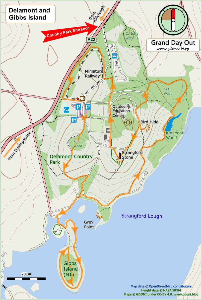
Delamont Country Park is one of the few areas open to the public which give access to the shore of Strangford Lough. There is a short section of shore trail and a prominent hilltop with great views over Strangford, the low hills near Downpatrick and, on a clear day, the Mournes beyond. Gibbs Island is a wonderful tranquil reserve with lough side walking, old woodland with a herony, a rookery and intriguing hints of previous human occupation. Combining the two into a single walk gets around the very limited access and parking at Gibbs Island and adds the necessary distance to get your head and senses tuned in to this precious piece of Strangford shoreland.

| TYPE | Undulating circular woodland and loughside walk in scenic parkland |
|---|---|
| DISTANCE | 4.2 miles / 6.8 km |
| SURFACES | Well made compacted surfaces with variable slopes. |
| HEIGHT GAIN / LOSS | 475 feet climb |
| HAZARDS | At high spring tide the section between Delamont and Gibbs island may require care or an inland diversion |
Getting There and Parking
Delamont Country Park is clearly signposted off the A22 Killyleagh / Downpatrick Road. There is a charge per car (currently at June 2019 £4). Facilities here include a cafe, toilet block, modern children’s playground and miniature ride-on stream railway.
The Route
Start at the end of the car park furthest away from the cafe / railway and just past the toilets. A tarmac road runs from here directly towards the Lough shore with the remains of the old Delamont House walled garden on your left. However, our route departs from this broad way almost immediately and bears right uphill on a crushed stone path.
Co Down is a landscape of Drumlins – a multitude of small glacial formed hills exhibiting a form often likened to the profile of a basket of eggs. This means lots of hill tops and human settlers have always been drawn to such places with their flat tops ideal for defence, agriculture, observation, religious rite and monuments. Add in this area’s proximity to the lough for transport and fishing and you have prime real estate with exciting development opportunities which didn’t go unexploited. Today you will see the this story told in the modern landscape.
You are now climbing up to Ring Wood – the name is the first clue that the wood marks a circular hilltop site. The young trees on your left give way to a mature stand as the path cuts into the heart of the wood. However, the most interesting part of this wood is its edge – notice how the circular stone wall which surrounds it drops steeply on the outside but is level with the ground within.

This looks like a wall better suited to keep things out than in – a hint that this may have been a defended site. The route now goes through the mature deciduous wood past the hilltop and out through a gap in the boundary wall past old gate posts. These are not ancient, but it is not unreasonable to guess that this gap still might mark the old access point to the circle.

As you exit the wood Strangford Lough with Gibbs Island lies directly ahead. To your left and slightly behind is the wooded hilltop which hides Delamont House and an overgrown rath / hill fort. From this vantage point previous residents would have seen boats travelling up the lough, including the long ships of the Viking visitors who called this place Strangr Fjörðr – strong sea-inlet. The fact that this name stuck and has been handed down to us suggests these seafarers were much more than occasional raiders and indeed may well have made up at least part of the previous population of the Delamont area.

Continue downhill bearing left at the next junction and then right as you rejoin the main vehicle track to the Lough. Look out for the substantial drystone wall which still separate the fields here.
Just before the the track reaches the loughside there is a black bench and a grass pathway cuts right to a stone stile on the Country Park Boundary. This is your crossing point onto the Lough Shore


Cross the stile and turn right to follow an unsurfaced path along just above the foreshore to where it joins a laneway. Turn left and follow this for about 50m where a another small path cuts back towards the foreshore, running just about the spring tide high water mark.

At very hide tide this section could be difficult, in which case, stay on the lane turning left at its end to access the Gibbs Island causeway.

Apart from bird life there are interesting hints of previous human activity here. Traces of what may be old fords have been found and on the far side, by the causeway stone wall, below the tide line may be the remains of a fish trap.
Continue to the causeway and cross over on to Gibbs Island.

The first thing you see is a cottage surrounded by an almost perfectly round wall topped with a thorn hedge. OS maps of around 1850 show this boundary clearly, so it is at least 150 years old. However, it could be much older given the strategic importance of guarding the causeway / access point to this island. Bear left through the gate past the National Trust sign and then left again to follow between fence and shore around a small oval mound topped with a number of thorn trees (another candidate for a ring settlement perhaps?)

The woodland and central mound of Gibbs island now lies directly ahead with a pair of stone pillars just visible marking a hole in the boundary wall. I suggest now walking a complete circuit clockwise around the woodland followed by an exploration through the stone pillars along the spine of the island on the path beyond.

If it is nesting season as you pass down the left side of the island you are likely to hear the loud harsh croaking calls from the Heron colony high in the tops of the pine trees. It is remarkable that a bird which is so well known for its patient silent fishing vigils on our lakes and loughs, is so unapologetically raucous when hanging out at home! Certainly secrecy plays no part in its nesting strategy!

At the end of the island you come to a channel with boat moorings and beyond this, low hills around the tiny settlements of Raholp and Saul . This is St. Patrick country – Saul (from the Irish Sabhall Phádraig, meaning ‘Patrick’s barn’) is said to be the site of his first church here and a relatively modern memorial statue is visible on the high point to the left. The waterway to your right once gave access to the Quoile river and Downpatrick (Dún Pádraig), but is now blocked by a tidal control dam. The settlement of Downpatrick has a long history as a regional seat of power and inhabitants of Gibbs Island beside this watery thoroughfare would have been in an ideal place to control access to it.
Continue around the island as the tidal barrier, the old stone quay and island cottage again come into view. I would now recommend turning back through the stone pillars to explore the heart of the wooded hill which features a rookery as well as the already mentioned Heron colony.

In summer the narrow unsurfaced path can become almost overgrown. Nettles thrive here, an indicator of high nitrogen content in the soil, which generally correlates with a history of human or livestock occupation!

Toward the island end the woodland floor becomes more grassy and the pines form a pleasant glade – a good place to stop and rest on a fine day.
From here you need to retrace your route back to the stone stile at the edge of Delamont Park by which ever way seems best.
Once back in the park turn right and follow the vehicle track as it runs parallel to the shore.

You now will pass another gap in the boundary wall – this one signpost to ‘Grey Point Viewing Area’. It is only 100m away through the gap and sharp right into the small copse (not along the shore) and then through the wood and out the other side to a nicely positioned seat with a good overview back to Gibbs Island – another good spot for a stop.
150m after the Grey Point path turn off the track splits in two. To the right is a dead end and turning circle, but you go left onto a footpath and start to climb away from the shore.

The field below you is used as a base for water-based activities including the annual Skiffie Festival and community boat races.
After 400m the path levels off before splitting – bear right here downhill again to Kinnegar Wood and its long pond.

This tranquil spot provides a home for many water birds including Coots and Moorhens (from mere [ie lake] hen). Their watery meanders can often be deduced from the trails they clear through the abundant water weed here.
Continue past the pond back into Nut Wood. This is a wood of two parts. On your left is a small area of complex old woodland and on the right and ahead very young planting carried out in the early 2000s by the Woodland Trust. The ground below the path is wet so water loving willows thrive here. Shortly you will come to a junction with a Woodland Trust information panel and a path leading to the lough shore. This tranquil dead end is worth a visit and it is your last opportunity on this route to get a look close up at the lough-side and its wildlife.

Continue around Nut Wood turning left at the next path junction, left as a vehicle track is joined and then right up a path to Delamont House (now an Outdoor Education Centre). It is currently being renovated (June 2019) having fortunately survived a recent rationalisation and now being allowed to continue its essential work.

The old manor sits adjacent to a large raised earthwork rath (hidden in the trees and now almost totally overgrown and inaccessible) . There is a continuity here – the local chieftain would once have ruled this area from a defensible secure highpoint with commanding views of all approaches. As the countryside became more secure the inheritors of this land would build a grand house whose fine views became a means to impress and entertain. Today, and in the future hopefully, these same views will inspire and educate.

Turn left and pass the house heading back towards the Lough, and after 100m you will see a low green wooden building below you. This is the bird hide and worth a visit for the opportunity to sit and take in the view alone. The intention of placing it here was to enable visitors to watch the coming and goings in the Herony below in the high tree tops of Kinnegar Wood. Unfortunately in 2019 the long established Heron colony seems to have largely gone – perhaps migrated to Gibbs Island. However, check this for yourself. At worst, watching birds which aren’t there is restful in a similar way, I imagine, to trying to catch fish which won’t bite! And if you watch for a time you will I am sure see something and gain a memory worth taking home.
Return from the hide to the path and continue out onto the headland and through a gap in a hedge and then make your way to the Strangford Stone.

On the 26th June 1999 a group of 1000 young people pulling on 20 ropes lifted this stone into its current vertical position. Is was a massive community project designed to give common focus and mark the start of a new millennium.
Follow the made path down past the information point (do have a read) to another gap in the hedge.

Here, almost absorbed by the thorn hedge around it, lies the steel case the Strangford Stone was transported in from the Mourne Mountains (see below and hopefully visible behind you). Viewing this cage and reading about the massive logistical and technological operation which brought it here and raised it, makes the achievements of our silent ancestors, who moved great stones by collective effort alone, all the more remarkable.

Now turn right and follow the hedge to join the vehicle track directly ahead which takes you past the old ruined farmyard and abandoned walled garden.

Continue ahead passing the walled garden and crossing the access road for the Outdoor Education Centre. After a further 100m the stone walled lane bears sharp right as a path branches off straight ahead .
Corbally Wood (option)


If you are still full of energy at this stage you might like to add an extra 1km loop to your walk to visit more Woodland Trust modern planting and the old hilltop of Corbally Wood. The main attraction on this section are the series of Strangford and drumlin vistas glimpsed through holes in the the old estate boundary hedge.
Main Route (continued)
You are now in a long thin planted beech wood which first appeared in the OS maps of 1900 labelled ‘Long Walk’, presumably an ornamental avenue of which little remains. Follow the path straight ahead and after 150m turn left. Cross the Country Park entrance road at a zebra crossing and turn right.
You are now beside the miniature railway line where real working steam trains regularly pass by at weekends and other peak times.

Follow the path parallel to the line, passing the engine shed as you re-enter the woodland. Continue for another 500m following the narrow strip of woodland between the railway and the high boundary wall. You now come to the old main avenue (gate lodge to your right). Turn left here and follow the avenue back to the car park and cafe.