
Winter Storm Damage blog statement
Subsequent to the severe storms this past winter many woodland paths and tracks remain impassable. In some cases the damage is so severe that the areas are closed for any kind of extended walking. In the coming months I will revisit as many walks as possible and update the blog accordingly. Please do not assume that walks are available as described and obey any closure signage you encounter on the ground.
Maps and photos note: click or tap to see any maps or photographs below as a high resolution version.

| TYPE | Circular walk up through natural wooded glen to open mountain and viewpoint and back along riverside. |
|---|---|
| DISTANCE | 0.75 miles /1.2 km |
| SURFACES | Mostly well made compacted surfaces with variable slopes. |
| HEIGHT GAIN / LOSS | 150 feet climb |
| HAZARDS |
|
Don’t be put off by the shortness of this route – it is a great little walk crammed full of woodland and heath richness with some of the best views in Fermanagh. It certainly wouldn’t fill a day, but it would be an ideal excursion between showers on a clear fresh day when the views will be at their best and the rocky Glen fills with cascades of tumbling water. It also combines well with the Lough Navar Forest Drive and other shorter stops at the Cliffs of Magho and Lough Achork. See map at end of this post for details.
Getting There
The easiest approach is to come from Enniskillen on the A46 Loughshore Road and after passing Ely Lodge Forest look out for road signs to Forest Drive, Churchhill and Derrygonnelly on your left. Follow the brown signs to the entrance of Lough Navar Forest Drive and park in the large car park located immediately beside the entrance to the forest drive.
The Route
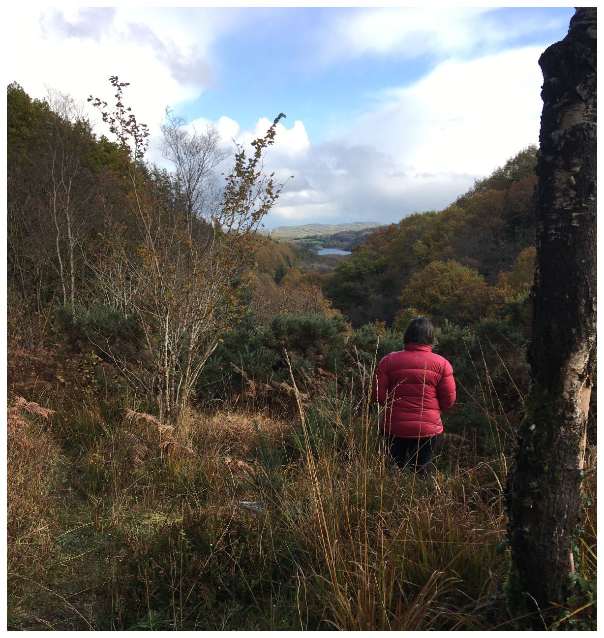
I recommend you start with a mini-excursion to the viewpoint associated with the car park itself. The path is narrow and a little overgrown, but leads to a glorious viewpoint (or possibly more correctly vista point) which frames a wonderful view down the wooded Sillees valley, over Carrick Lough and then beyond to Topped Mountain behind Enniskillen. One of the main attractions of this walk is the sense of place as a ‘hidden valley’ – a place both fertile and wild, slightly set apart from the lakeland below, with a long history of habitation.
Retrace your steps to the car park and then cross over the Glennasheevar Road to enter Correl Glen Reserve just above the old bridge past the reserve information board.

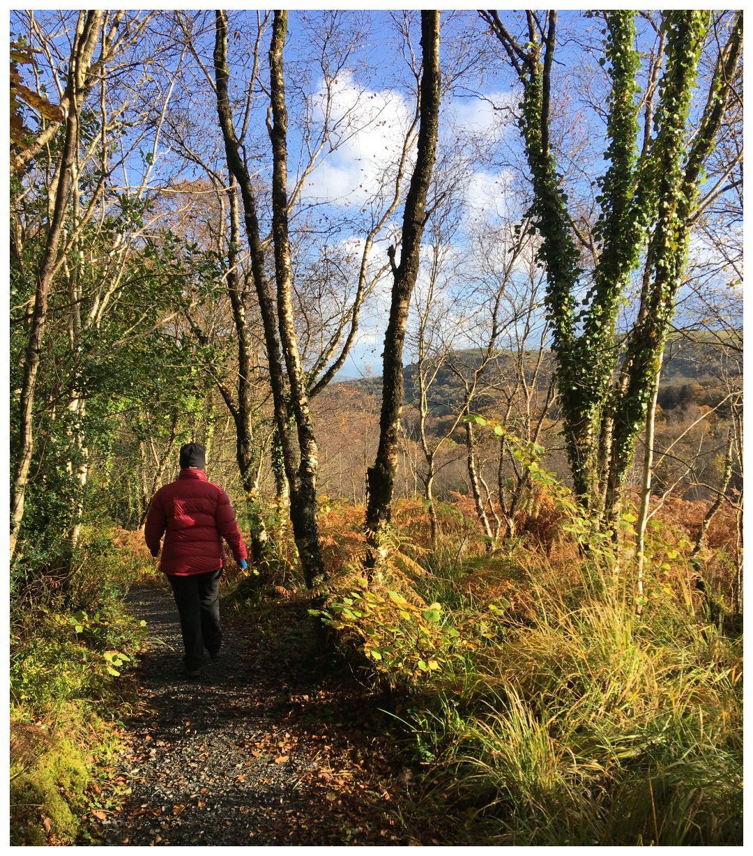
You are immediately in a very different woodland from the coniferous plantation by the car park. The trees are native, mainly oak, birch and ash.

However, what really stands out here is the richness of the woodland understorey – the shrubs, bushes and smaller trees which live below the woodland canopy. There is greater humidity here, shelter and shade which leads to a proliferation of ferns, mosses and fungi. These in turn encourage nutrient recycling, which provides a favourable habitat for any animals and plants.
Just inside the wood turn right to climb sharply uphill along a small zig-zagging path. After about 50m you come to the edge of the woodland and views behind open up over Navar Forest.

You are now on a beautiful enclosed area of marshy heathland with bracken, heathers and aromatic bog myrtle. The path continues to climb and the view to open up until Carrick Lough and its crannog becomes visible among the low rolling hills below. This beautiful valley was singled out by famous Irish Naturalist Robert Praeger (founding member of the Belfast Naturalists’ Field Club) who wrote:
The limestone area around Carrick Lake (Carraig, a rock) and Bunnahone Lake (Bun na hAbhna, the river foot) near Church Hill is highly picturesque, like a kind of condensed Switzerland—barring the snow: instead of that, great shelter and moisture prevail, as is shown by the luxuriance of the vegetation. Correl Glen is a ravine choked with huge blocks of sandstone, covered by a canopy of gnarled Birch trees; boulders and tree-trunks alike are smothered in mosses and Filmy Ferns—Cow-berry also, unexpectedly—making a sort of strange fairyland. Further up, Carrick Lake is romantically situated, with grassy limestone hills rising from one shore and heathery sandstones from the other.
Praeger, R L (1937) ‘The way that I went’ ‘
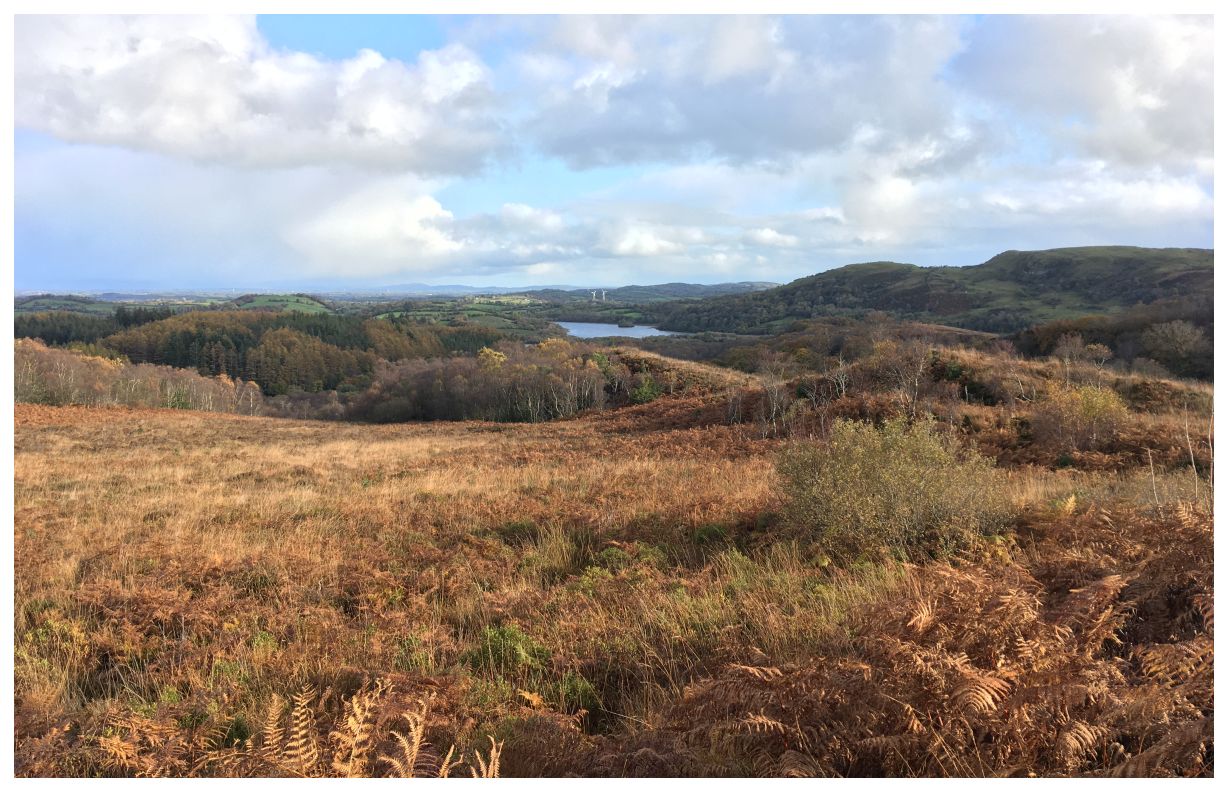
Continue past a seat and information board to the upper viewpoint. The view is little changed from that which Praeger described, although Carrick Lough now comes in two instalments -sediment having filled a middle part with a low-lying marsh.

The woodland of Correl Glen is also now rather more than “gnarled Birch trees“. Today with its high canopy of oak and ash and rich verdant understorey it may suggest to us the undisturbed ancient Irish Wood, However, the Ordnance Survey First Series (1832 – 1846) shows no woodland in the upper Glen at all! The Northern Ireland Ancient Woodland Inventory shows semi-natural and planted ancient woodland areas only in the lower Glen. So what we see here today in the upper Glen is testimony to nature’s ability to recolonise and repair itself given the opportunity!
Retrace your steps downhill to the woodland edge where you turn right to follow the path along the heathland boundary.
This micro-climate and the sheltered valley below has also long cradled a human population. As well as the crannog of Carrick Lough, Bunnahone Lough has three crannog sites while there are a further fifteen visible ring forts in the valley and hills in this small area. You can imagine that a crannog here, away from the big lough (and potentially unwanted big visiting boats) would have offered security, shelter and rich land for hunting and growing. Around 1500 Gilbert Ue Flannagain, the local chieftain, built a church on the south shore of Carrick Lough directly overlooking the crannog. Today the ruins and graveyard are still visible, surrounded by woodland, but far from any track or access.

Your path now turns back into the woodland and drops down to run upstream along the Sillee River.

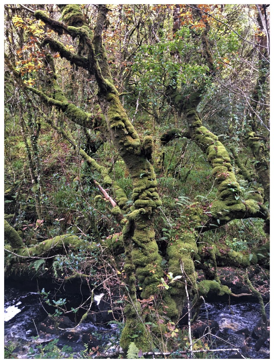
The sheltered micro-climate here supports an abundance of plant and insect life including the Silver-washed Fritillary – the largest butterfly in Ireland.

Probably the most striking feature of this section is the enveloping mosses which encase the matures trees like some super-green insulation!
All too soon you will arrive back below the Falls Bridge where, with care you can descend to the river’s edge along a short rocky path.

Leaving the river, exit by the gate you earlier entered and return to the car park opposite.
Route Map to Download and Print (PDF)
External Links
- Correl Glen Nature Reserve – Dept. of Agriculture, Environment and Rural Affairs
- Forest Understorey – Wikipedia