
The 7 mile Navar Forest driving route is a pleasant outing in itself, but can be greatly enhanced by adding on a bit of walking. The Blackslee Waterfall Walk and the nearby superb Correl Glen Nature Reserve and Carrick Viewpoint Walk are each described in their own posts. This post pulls together other short options which might suit changeable weather or a less active party of travellers.
If you are planning to travel to do the Navar Forest drive, it is worth checking on the Navar Forest NI Direct page for details of road closures etc. before you leave home. It is very much a working forest and access cannot be assumed.
Getting There
The easiest approach is to travel from Enniskillen on the A46 Loughshore Road and after passing Ely Lodge Forest look out for road signs to Forest Drive, Church Hill and Derrygonnelly on your left. Follow the brown signs to the entrance of Lough Navar Forest Drive.
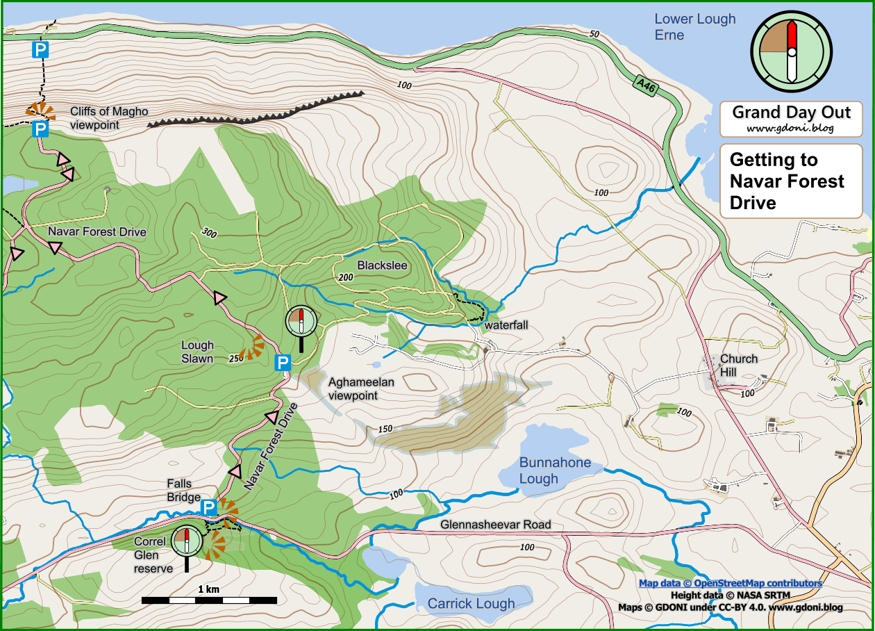
There is a small car park at the Forest Drive entrance – opposite Falls Bridge and the Correl Glen Nature Reserve (link to walk). Park here and look for a small rather overgrown path just behind the car park. A few metres along this way you will come to a hidden viewpoint with a superb view down along the Correl Glen valley, over Carrick Lough to the hills beyond.
Now start the Forest Drive proper and continue to the Aghameelan viewpoint. This is well worth a stop in its own right but is also the starting point for the Blackslee Waterfall Walk.


Continuing on uphill you next come to a small car park on your right which serves the Lough Slawn path.
Lough Slawn and the Old Firetower path

From here a short Y shaped walk climbs, passing crags and up to a plateau with a small mountain lough. The whole route is only 0.6 miles long, involves about 80 feet of gradual climb and is undulating but generally good underfoot.
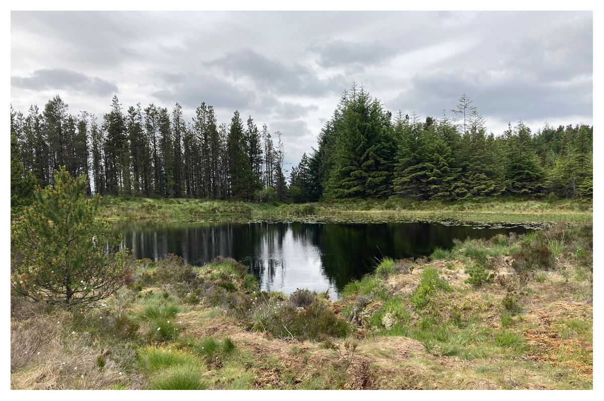
Lough Slawn is a natural feature that predates the forest plantation. The 1830 OS map shows it on open land with clusters of small fields in the valleys below. Further back it may well have been surrounded by mature oak, rowan and ancient native woodland. The damp semi-open terrain the path passes through is full of mosses, mist loving planets and a multitude of insects including spectacular Damselflies.
You now retrace your route a little and then branch right and up again to a viewpoint that sits over 900 feet high on a rocky spur. There is a seat here that should be used and time taken to study the views below. You will notice a substantial square of concrete here – the base of a former forest fire watchtower. In the 1960s and 70s these were common in forests and hark back to an age when most large public forests had their own foresters and team of workers. They prepared the ground, built the forest tracks and recreational pathways, planted the trees, thinned them as they matured, watched and controlled fires, operated forest caravan sites and facilitated educational visits. Modern efficiency has swept all this away – along with many of the benefits which came with it.

You will also see a small line of raised stones here. This is not a listed place on the Northern Ireland Sites and Monuments Record database, but the surrounding area is full of raths, crannogs and standing stones. Perhaps the stones here are natural, perhaps a forester arranged them like this, but whatever, it is still very likely that this would have been a significant place to the ancient peoples who lived in these lands.
Now retrace your steps back to the access car park.
Continue uphill along the forest drive to a point were it becomes two-way as it approaches the Cliffs of Magho viewpoint. All the forest here has recently been clear felled, so the views are open but rather desolate. On reaching the road end you are rewarded with an expansive panorama over much of Lower Lough Erne, with the Bluestack Mountains of Donegal forming the far horizon to the north.

The large viewpoint car park is fronted by a section of linear path which runs for a short distance before abruptly terminating. There is also a waymarked path which descends steeply from the east end of the car park, dropping over 700 feet in just half a mile to a car park on the main A46 below.
Retrace the drive to where it again becomes one-way and you turn right and continue on. After another 2km you come to an optional turn-off to Meenameen Lough. This is the starting point of a 7 mile forest track walk which is described on the Marble Arch Geopark Site. The walk description includes a nice map, but be aware it is not orientated with North at the top so can be rather confusing! The walk includes a visit to Lough Navar itself which the forest drive route omits!
Continuing on the main forest drive you soon come to a distinctive rock feature known as “The Old Man’s Head”. Beside this is a small car park which serves the fishermen and walkers who visit Lough Achork.
Lough Achork

A well surfaced path drops down from here to circumnavigate Lough Achork. The whole route is only a mile long with about 75 feet of climb.
The Lough is bounded to the North with low cliffs and sits between two low ridges giving it the feeling of a secret place.

You are now on the final downhill section of the Forest Drive. At a right angle bend 250m before re-joining the public road you may see a sign for the final visitor attraction – the “Sweat House”. There is no parking here (June 2021) and the route to it looks very overgrown. I confess I have not yet explored the remains of this ancient Irish Sauna – but it is on my to-do list for a future visit.
Back on Glennasheevar Road you turn left and after 1.7km you find yourself back at the Forest Drive starting point at Falls Bridge.
Route Map to Download and Print (PDF)
External Links
Related Walks